
 LAST PAGE
Combe Haven Valley, East Sussex.
Simon Jennings (University of North London) & Christine Smyth (Leighton Park School, Reading)
Unpublished Report, May 2001
Introduction
We conducted a stratigraphic survey in the area of the flood plain near Monkham Wood (Fig.1) during July/August 2000.
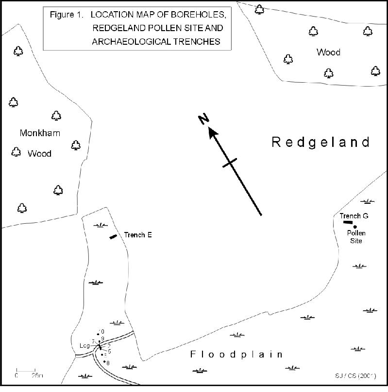
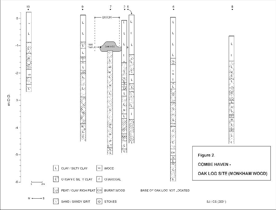
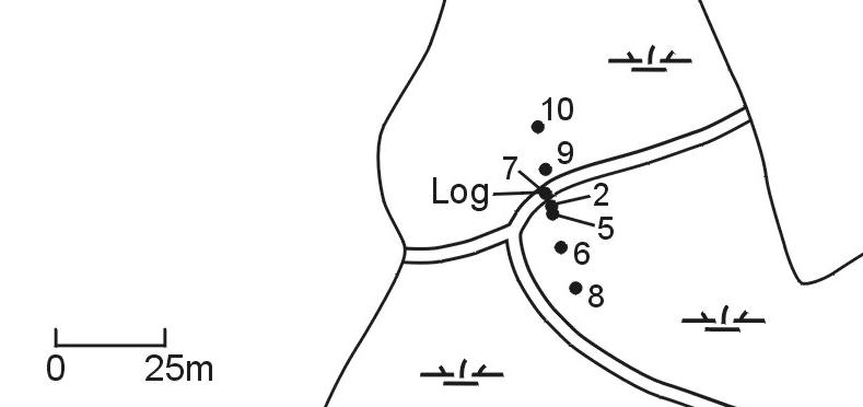
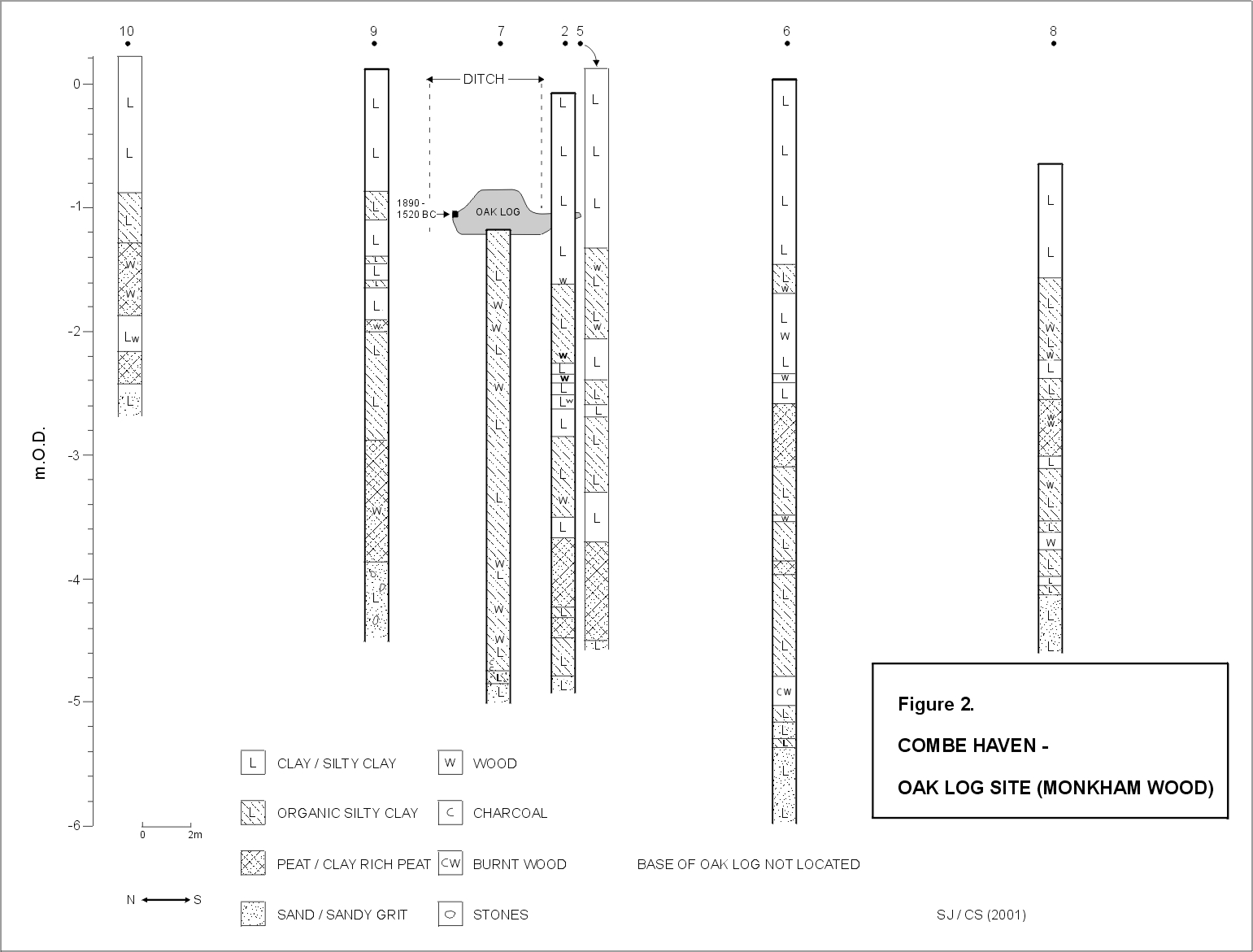
Ten auger holes were sited in a transect across a drainage ditch in which an oak log was located.
A detail of the location is shown here
Coring was undertaken to a depth determined by the presence of a stiff sand or sandy grit, which underlay largely organic sediments. Most of the log had been uncovered when the ditch was deepened mechanically, but part of it was embedded in the southern bank of the ditch.
The aim of the investigation was to establish the stratigraphic position of the log, and in particular its relationship to the ditch and associated banks to ascertain whether the site had archaeological potential.
Note that on figures 1 and 2, auger holes 1, 3 and 4 were positioned very close to auger hole 2, and are not shown. The purpose of these auger holes was to locate the buried portion of the log prior to excavation.
Description of the log
The northern end of the log is forked, being probably the result of natural branching, but also has been notched artificially, sometime in the past. The middle section was largely in tact, but the southern section has had its centre removed, either due to decay or possibly as a result of human activity. This hollowed-out section, coupled with the smooth, possibly fashioned nature of its outside, resembles a pre-historic log boat.
Stratigraphic position of the log
The log lies orientated across the ditch, with the southern end embedded in the bank, from which it had to be excavated. The northern end of the log, which was exposed in the ditch, rests on the upper surface of the organics, while the southern end was clearly embedded within the overlying silty clay of the ditch's bank (Fig.2).
A large plan for detailed study is shown here
A sample of wood for radiocarbon dating was taken from the northern part of the log, by Nick Austin. The resultant analysis, 1890-1520 BC, places the age of the log in the middle Bronze Age. The upper surface of the organics that much of log is in contact with, had been dated at neighbouring sites, as reported previously by ourselves, to the Iron Age or late Bronze Age, although due to sediment being excavated by ditch deepening, it is possible that the organics associated with the log are older.
However, the relationship between the southern end of the log, and the silty clay sediment of the ditch bank is unclear. It is unlikely, given the very cohesive nature of these sediments, that the recent deepening of the ditch mechanically, forced the log into the bank. It is more likely that the log had become buried by silty clay being deposited on top of it, either naturally or by human activity. It is not possible to conclude which of these two processes were responsible for burial or when. However, if this was the first time that deepening of the ditch artificially had exposed the log, then the following assumptions could be made:
1. The present position of the log predates the change from estuarine to freshwater conditions in the valley, and presumably the resultant spread of agriculture and drainage ditches onto the flood plain, from around the 12th to 14th centuries.
2. We have established from previous work in the valley, that much of the silty clay that overlies the organic layers, was the result of slope disturbance during the late Bronze Age and Iron Age due to forest clearance. This colluvial sediment was deposited within the lower reaches of the Combe Haven, which, at that time, were estuarine. These estuarine conditions were established between 2100 to 2400 years ago. It is possible that the log was reworked during this phase, with at least the southern section lifted from the earlier (middle Bronze Age) organic layers, and subsequently buried as the inorganic sediment built up.
It is important to stress that these assumptions only hold true if the log has remained undisturbed in the ditch.
The relationship of the ditch with the flood plain and the stratigraphy
It is likely that the position and course of many of the drainage ditches on the flood plain relate to former, more natural water courses, either estuarine creeks or small streams that issue from the slopes. However, the 'oak log ditch' does not appear to conform to this pattern, being orientated across the 'entrance' to a small side valley.
It is noticeable that the elevation of the log is similar to the height of the flood plain surface at auger hole 8 (Fig.2). It is equally clear that the elevation of the organics suddenly increases from the ditch northwards (i.e. up valley), while the surface elevation of the silty clay remains fairly consistent between auger holes 2 and 6, i.e. down valley from the ditch, with the thickest sequence of silty clay being recorded there. This lack of conformity between the two surfaces can be explained by ditch spoil being deposited on the flood plain side of the ditch (i.e. from the ditch to the position of auger hole 6). This is clear today, where recent ditch spoil has been preferentially dumped in that area. This overburden of spoil may have resulted in compression of the underlying organics, and thereby resulting in their lower elevation immediately south of the ditch compared to that north of the ditch.
However, the question arises as to why establish a drainage ditch by embanking its southern (flood plain) side, when originally there was very little difference between the elevation of the base of the ditch and the elevation of the adjacent flood plain? It is likely that part of this ditch marks the course of a former creek, as discussed above, but its extension right across the entrance to the small side valley is anomalous, and may owe more to human activity than to natural processes.
A valley-side cut-feature
The possibility that the full extent of the ditch, and its associated southern bank, owes more to human activity than to natural processes, is supported by its cross-sectional shape approximating to that depicted on figure 3.

This feature is characterised by an up valley slope, a ditch and a down valley increase in elevation before sloping down to the flood plain. An examination of the surface elevation of the auger holes shown in figure 2, from 10 to 8, reveals a close similarity with the surface shown in figure 3, but with the ditch having had its edges sharpened-up.
This may seem unremarkable, until a comparison is made with the surface profiles of Trenches E and Trenches G (location shown on figure 1), as published in the Wessex Archaeology Report 39211 c on Upper Wilting Farm (May 1996). The profile of these trenches, on the valley side to flood plain axis, also conforms to that shown in figure 3. Wessex Archaeology concluded that this topography was the result of land slips, but provided no supporting geological or geomorphological evidence to substantiate this. Furthermore, investigations at Redgeland by ourselves (see 'pollen site' on figure 1 -work in progress), has shown that just approximately 4m from the flood plain-end of Trench G is located a substantial deposit of burnt stones with charcoal, buried beneath an organic layer. Charcoal from the burnt stone layer has been radiocarbon dated to the middle Bronze Age. Pollen associated with the organics has considerable amounts of hazel, and a piece of hazel wood has evidence of being worked, suggesting woodland management. The presence of Bronze Age hearths on nearby slopes, the pollen site at Redgeland, and possibly the oak log site, together indicate substantial use of the area around Monkham and Redgeland during and since the Bronze Age.
Archaeological heritage
Work undertaken in the Combe Haven Valley, especially since the 1980s, has shown increasingly, that this area has a rich archaeological heritage. This conclusion can be drawn despite the lack of any extensive archaeological investigations being conducted in the area. Should a by-pass be built through the valley, a full and scientific assessment of this heritage should be undertaken prior to any construction activities.
Simon Jennings, Christine Smyth
16th May 2001
INDEX